
Very little remains of Abil al-Qamh in Safad, northern occupied Palestine. The village was ethnically cleansed and occupied by the Haganah terrorist militia on May 10, 1948. (Photo Credit: Palestine Remembered)
Stolen By a Map: The Haunting History of Lebanon’s Lost Villages
Fear had already gripped their hearts. For the past month, ever since news of massacres in nearby villages began to spread, the residents of Tarbikha had been sleeping outside in a field. Fatima Hourani's husband, Deeb, and the other men took turns guarding the village at night. Nothing could have prepared them for what came next.
Fatima was outside when she saw armed men racing down the hill toward her village. They arrived in tanks, carried rifles, and wore British uniforms with dome-shaped helmets. Their complexions ranged from very pale to deeply tanned. She didn't know who they were — only that they were terrifying. She stood frozen in place until her sister-in-law abruptly yanked her back to reality.
“People are fleeing,” her sister-in-law snapped. “And you want to stand there and watch?”
At 94, Fatima still vividly remembers the chaos: people scrambling in all directions, her in-laws frantically packing their belongings, her mother-in-law slipping property deeds into her bag, and her father-in-law handing her a stack of plates to balance on her head. Nine months pregnant, she struggled under the heavy load. Luckily, her family made it out before the militiamen reached their house. By the time they arrived at the village center, she says, residents were already fleeing.
“Some took the house keys with them; we didn't even bother to lock up,” she told The Public Source. “Even the chickens were running out of fear.” She paused, a flicker of pain crossing her eyes as she glanced at the wall. “Why do you bring back these painful memories?” she asked, her voice trembling.
The soldiers Fatima saw were members of the Haganah terrorist militia, named after the Hebrew word for “defense.” The Haganah was one of the main Zionist paramilitary organizations responsible for the Nakba, the ethnic cleansing of Palestine. After May 1948, it became central to the nascent state’s official army. The militia-turned-army entered Tarbikha at the end of that year, forcing its residents to flee on foot, and leaving the village desolate and barren.


It took almost a full day for Fatima and her family to reach the nearest safe haven: a simple stretch of green known as Khalet Wardeh. Soon after, a friend of her husband's invited them to stay in the nearby Lebanese village of Aita al-Chaab. From there, their journey took them through different villages in southern Lebanon: Aita, Yater, Haddatha, Maarake, and eventually to Abu al-Aswad, near Adloun, just south of Saida.
The Houranis (editor's note: no relation to the author) went from being farmers on their own land, in Tarbikha, to laborers on someone else’s farm. The landowners they worked for treated the Houranis well, allowing the family to set up and live out of a tent on their land. But rebuilding their lives from scratch while raising 10 children proved to be a daunting challenge.
“I would often see my father sitting under a tree, tears in his eyes, reminiscing about the old days in Tarbikha and all that we've lost,” Fatima's son, Mahmoud Hourani, told The Public Source.

Mahmoud Hourani, author of “The Case of the Seven Villages,” at his home in Adloun. Hourani still has hope, and dreams of returning to his ancestral village of Tarbikha. March 16, 2024. (Rita Kabalan/The Public Source)
Tarbikha shared the fate of much of historic Palestine: Zionist militias expelled the Indigenous population to make way for a settler-colonial ethno-state, built on systematic colonial atrocities and dispossession — structures of violence that persist to this day.
But Tarbikha and six of its neighboring villages — Abil al-Qamh, Hunin, Nabi Yusha, Qadas, Salha, al-Malikiyya — are central to a distinct chapter in the ongoing history of settler colonialism, imperialism, and mass displacement. The story of Lebanon’s "Seven Lost Villages," located in the ambiguous region between northern Palestine and southern Lebanon, underscores the arbitrary power of lines drawn on a map. Its origins trace back to the aftermath of World War I, when the French and British colonial mandates delineated the borders of Lebanon and Palestine against the interests of the native populations.
Before the Franco-British demarcations, these villages were part of the tapestry of small communities and farms across what is now southern Lebanon and occupied northern Palestine. After the early 1920s, when the new borders placed them on the British side of the line, residents of these villages continued their lives much as they had before, but were now living under British Mandate Palestine. During the Nakba, however, Zionist militias like the Haganah began ethnically cleansing these and other villages across the region. Forced to seek refuge at the nearest safe haven, the original residents of these seven villages fled to their relatives, friends, and former neighbors in what was by then Lebanon.
Confronted with the harsh reality of being unable to return home, they began rebuilding their shattered lives, despite limited resources, the pain of displacement, and a prolonged struggle to secure Lebanese citizenship — a right the Lebanese government denied them for years. Today, Israeli settlements occupy the lands where the original seven villages once stood, and — as a testament to the occupation's longstanding attempts to falsify and erase history — the villages’ Arabic names were replaced with Hebrew ones. The Arab villages of Abil al-Qamh, Hunin, Nabi Yusha, Qadas, Salha, al-Malikiyya, and Tarbikha were renamed Yuval, Margaliot, Ramot Naftali, Yiftah, Yir’on and Avivim, Malkia, and Shomera respectively.
Settlers who occupied Tarbikha remodeled some of the houses they stole; others, like in Qadas, completely destroyed the homes. They turned historical sites into tourist attractions and farms like the Hourani’s into agricultural plains. The occupying forces built military bases on some of this land, like in al-Malikiyya, with prime views into southern Lebanon — all part of the ongoing effort to further encroach on the region.
History of Colonial Greed
During the Ottoman era, from 1516 to 1918, there were no defined borders separating Palestine from Lebanon. The villages of southern Lebanon, including the seven mentioned in this article, were part of a larger region known as “Jabal Amel.”1Following the defeat of the Ottomans in World War I, France and the United Kingdom seized control of the eastern Mediterranean as mandatory powers. In 1916, British diplomat Mark Sykes and French diplomat François Georges-Picot drafted a secret agreement in service of their countries’ imperial interests in what would eventually become known as the Sykes-Picot Agreement. This accord laid the foundation for the borders that would shape the modern states of Palestine and Lebanon. A year later, on November 2, 1917, British Foreign Secretary Arthur Balfour sent a letter to British Zionist leader Lionel Walter Rothschild, expressing support for “the establishment in Palestine of a national home for the Jewish people.” The declaration encouraged the Zionist movement to push British authorities for more land — including the British annexation of parts of southern Lebanon.2
The Zionists fought against the original borders proposed by the Sykes-Picot Agreement, which placed Lebanon's southern boundary 24 kilometers north of Haifa, extending to Lake Tiberias.3In 1919, four Zionist organizations wrote to the post-World War I Paris Peace Conference, advocating for Palestine's northern border to extend from Saida to Qaraoun. The organizations wanted complete control over the Litani river, some 29 kilometers further north of the Sykes-Picot demarcation.4 Although France remained adamant about retaining the Litani within Lebanese territory, leading Zionist organizations urged the British to apply more pressure on the French.5
On September 1, 1920, France’s High Commissioner of the Levant Henri Gouraud declared the creation of Greater Lebanon within its “natural borders,” including the villages of Jabal Amel.6 The final demarcation of the southern border was deferred to a future international agreement between France and Britain, the first version of which came in December of that year.
In December 1920, the Franco-British Paulet-Newcombe Commission started negotiations to finalize the border between British Mandate Palestine and French Mandate Lebanon. By the time negotiations were over, Palestine's northern boundary was demarcated from Ras al-Naqoura to Metulla.7 Lebanon had lost between 30 and 40 villages; estimates vary since many consisted of open farmlands, fields, and small clusters of houses. The most notable among these are the seven villages that are now commonly referred to as the "Seven Lost Villages,” according to Amine Hotait, a senior officer at the Military Academy who verified the Israeli withdrawal from southern Lebanon in 2000 as head of the Lebanese Border Demarcation Committee (editor's note: Amine Hotait (1949-2024) passed away a few months after our interview with him earlier this year).
France and Britain signed the Paulet-Newcombe Agreement in 1923, completing the legalities by 1926. France, however, had conducted a population census in Lebanon in 1921, prior to the conclusion of the Paulet-Newcombe Commission's work, and had already granted Lebanese citizenship to the inhabitants of the annexed villages. Just five years later, the residents of these villages lost their Lebanese citizenship, an administrative formality that would alter the course of their lives. They hadn’t moved; the borders had shifted beneath their feet — eventually stripping them from the land they called home. Now living under the British Mandate, they were reclassified as Palestinian citizens.8
A Secret Accord
In 1915, as World War I was raging, and the Ottoman Empire was collapsing, the Entente Powers (led by Britain, France, and Russia) began secretly negotiating the future borders of the Middle East.
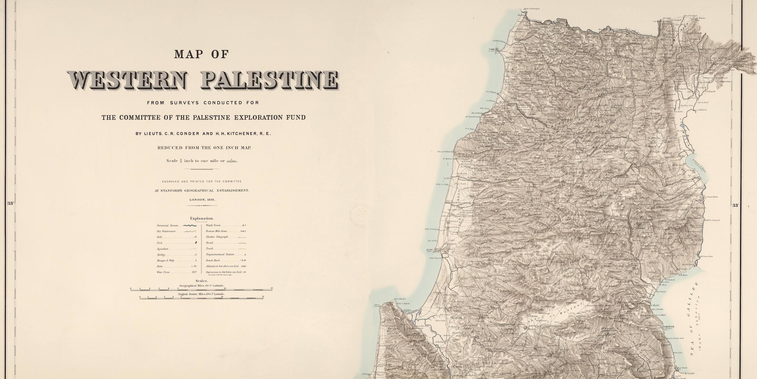
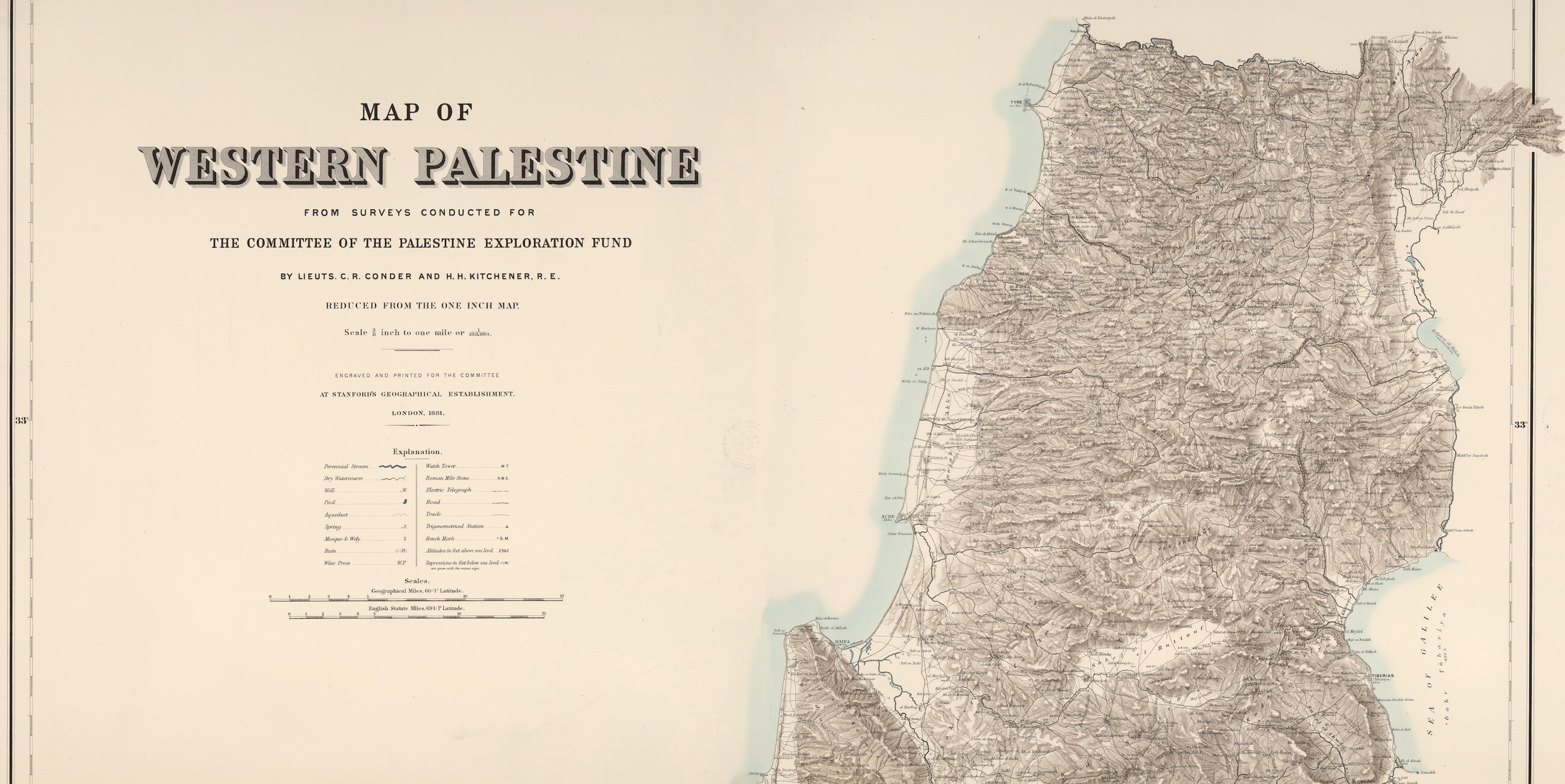
Palestine, 1881
This map, from 1881, shows a dense scattering of Arab villages in the areas now known as northern Palestine and southern Lebanon. It was commissioned by the Palestine Exploration Fund, a British society founded in 1865, with strong religious interest from Christians, to carry out exploration (and intelligence-gathering) in Palestine. It is the oldest organization in the world created specifically for the study of Palestine.
The Sykes-Picot Agreement of 1916
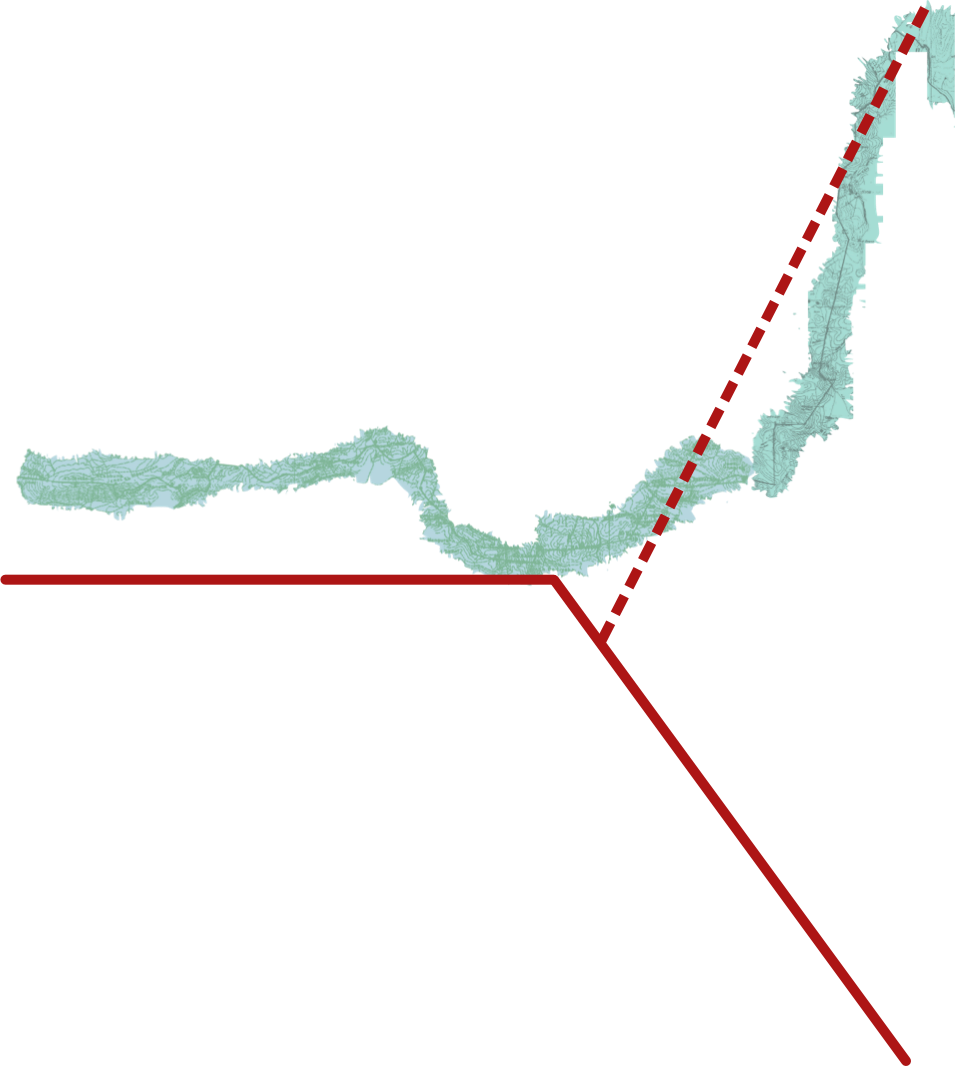
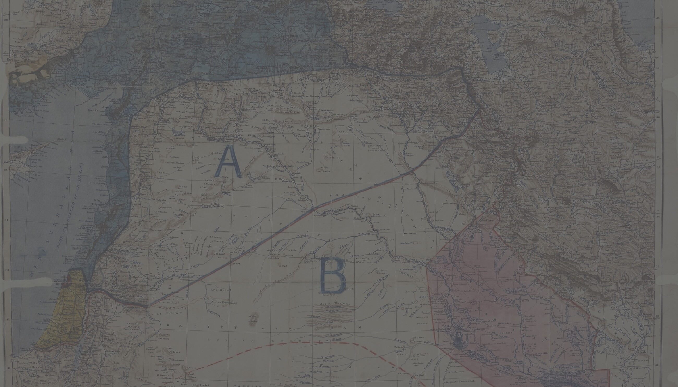
In 1916, British diplomat Mark Sykes and French diplomat François-Georges Picot announced the Sykes-Picot Agreement. It divided all the Ottoman provinces outside the Arabian Peninsula into nominally independent areas, with limited self-rule, under British and French imperial control.
The red line, below, is the initial Sykes-Picot border between the British- and French-controlled areas. (The dotted line represents a later proposal, called the Millerand Line, made in 1920.)
The Territorial Claims
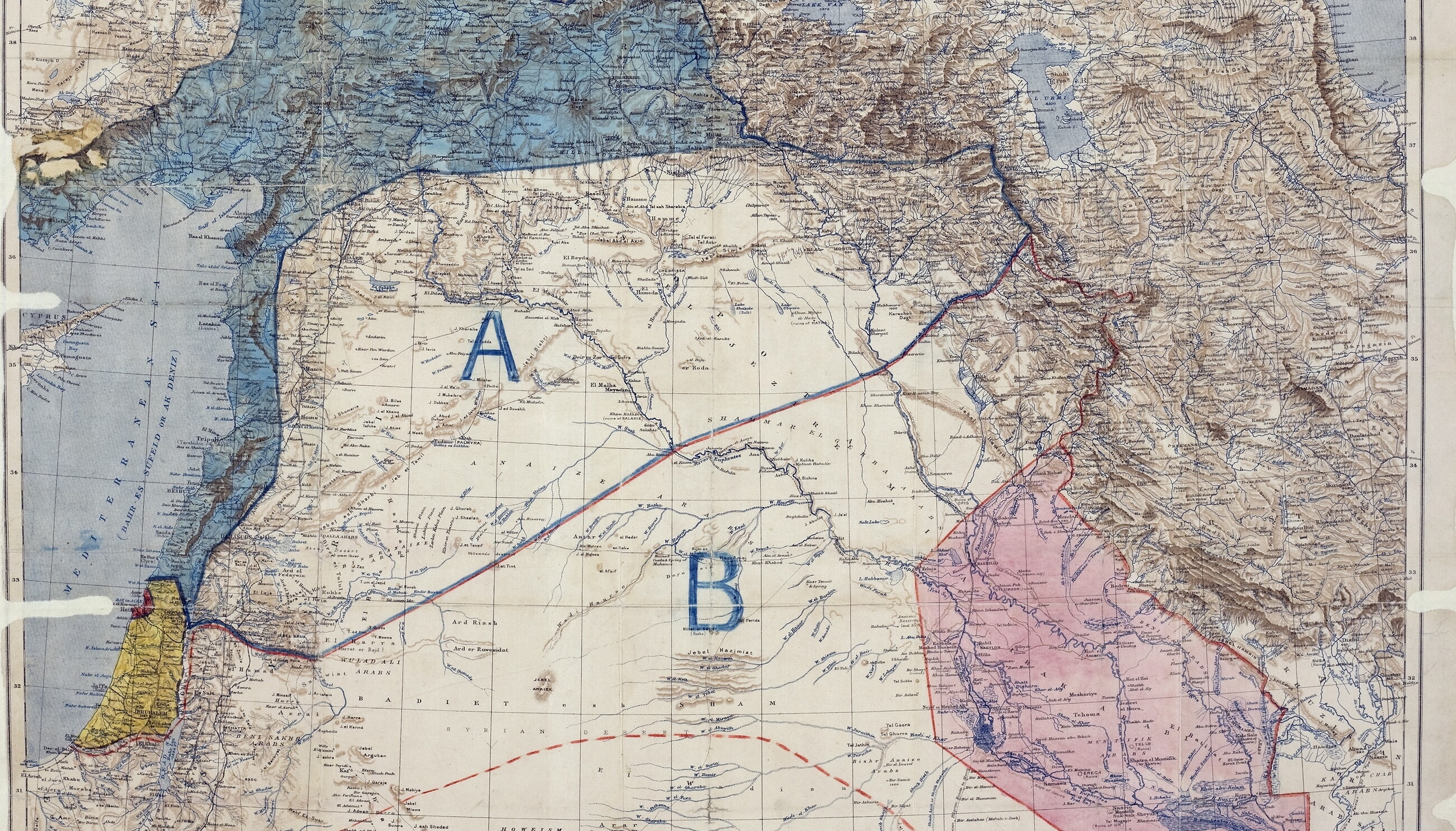
This map lays out the broader Sykes-Picot agreement in the Arab lands. The map divided British and French interests into areas of direct control (the pink- and blue-shaded areas, respectively) as well as nominally "independent" areas of influence in the central Arab lands. Those were Zones A (the French) and B (the British), divided by the red and blue line on the map.
Imperial Dreams
The British originally envisioned their mandate as covering the lands that are today southern Palestine, Jordan, and southern Iraq, where they had a treaty with the Ottoman Petroleum Company. They also claimed small enclave, shaded in red on the map, comprising the ports of Haifa and Acre, giving them access to the Mediterranean for an oil pipeline terminus. France would rule the blue-shaded areas along the Mediterranean coast directly — from al-Zib (Achzib), through present-day Lebanon and Syria, all the way to Anatolia and Kurdistan. The bulk of Palestine, including Jerusalem, would be internationalized.
Occupied Enemy Territory
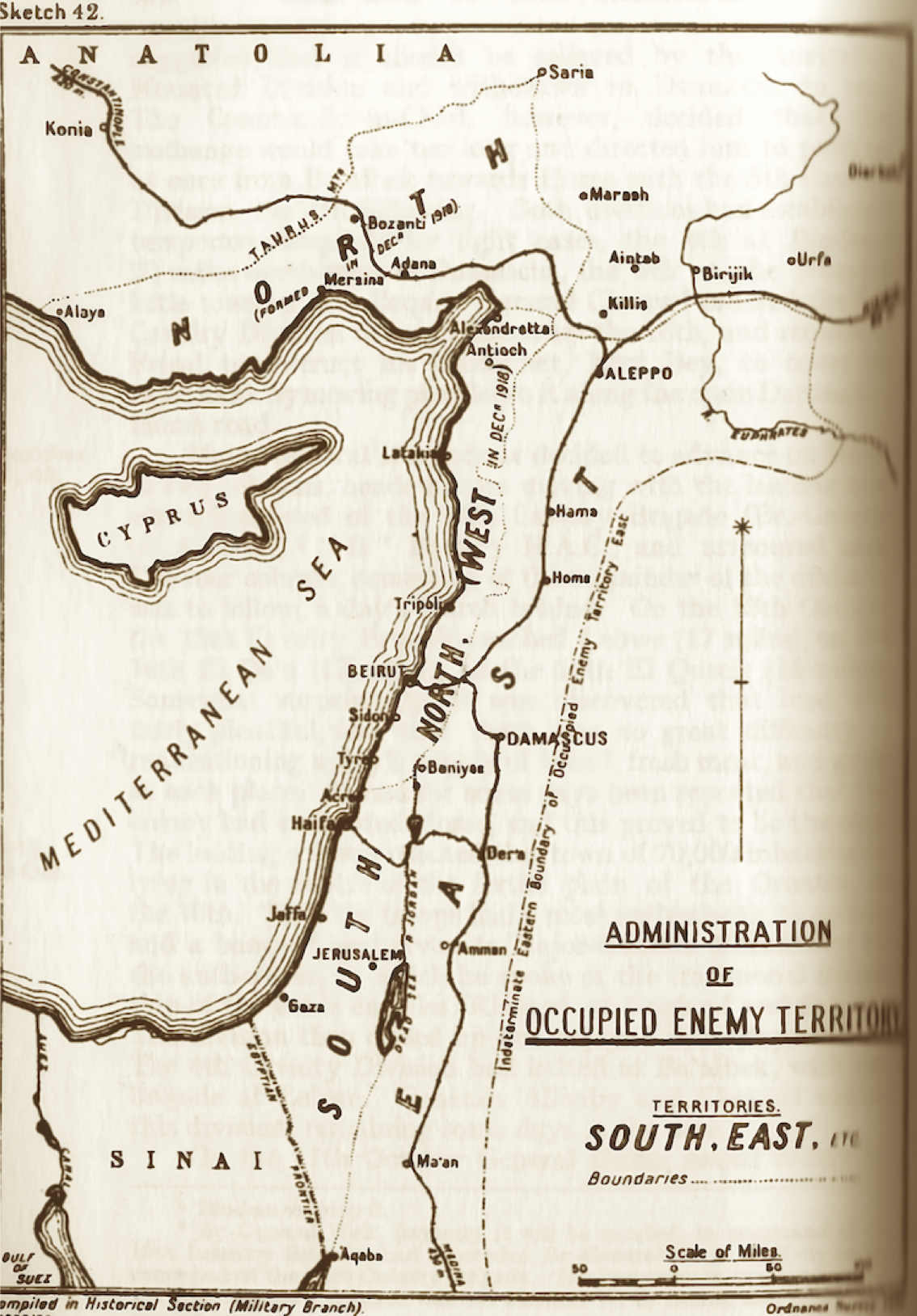
But as the Ottoman Empire collapsed, and Western powers increasingly occupied the region, the British and French empires began to renegotiate the borders. They set up demarcations within what they referred to as "Occupied Enemy Territory Administration” (OETA). The goal was to avoid conflict with the newly established Hashemite Syrian Arab Kingdom in Damascus, under King Faysal, a British ally who had led the Arab Revolt against the Ottomans.
This map shows the region's internal borders as of December 1918. Britain controlled OETA South, France controlled OETA North West, and Faysal — for now — led OETA East (although Faysal's constitutional monarchy would soon fall to France).
The Zionist Movement
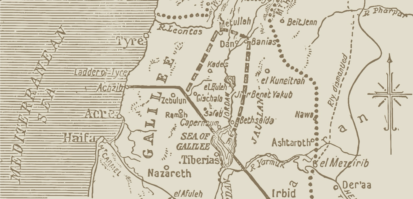
The Zionist movement, an international movement founded in 1897 by European Jews at a conference in Switzerland, envisioned an eventual Jewish state. Lord Arthur Balfour's famous 1917 Declaration promised it "a national home for the Jewish People" inside British-occupied Palestine. At the 1919 Paris Peace Conference, Zionist leaders pushed to radically expand the boundaries of the British mandate.
The grey-shaded area of this map shows the Zionist Movement's ambitions. Reaching far inside modern-day Lebanon and Syria, their proposed claim would have given the new Zionist state significant water rights over the Litani River watershed and the Jordan headwaters. (The smaller dashed lines on the map, above and bisecting the grey area, shows the regional railways.)
Shifting Lines
But the French refused to give up all of the territory — including key water and railway rights — that the British and the Zionist Movement demanded. In 1920, the British and French began a new series of negotiations over the regional boundaries.
This map shows how those borders shifted. The solid line represents the original Sykes-Picot boundary of 1916; the dotted line shows the British and the Zionist demands in 1919; and the dashed line delineates a less ambitious compromise proposal.
In the meantime, Mandate authorities on both sides of the borders began conducting censuses and issuing ID documents.
A New Middle East
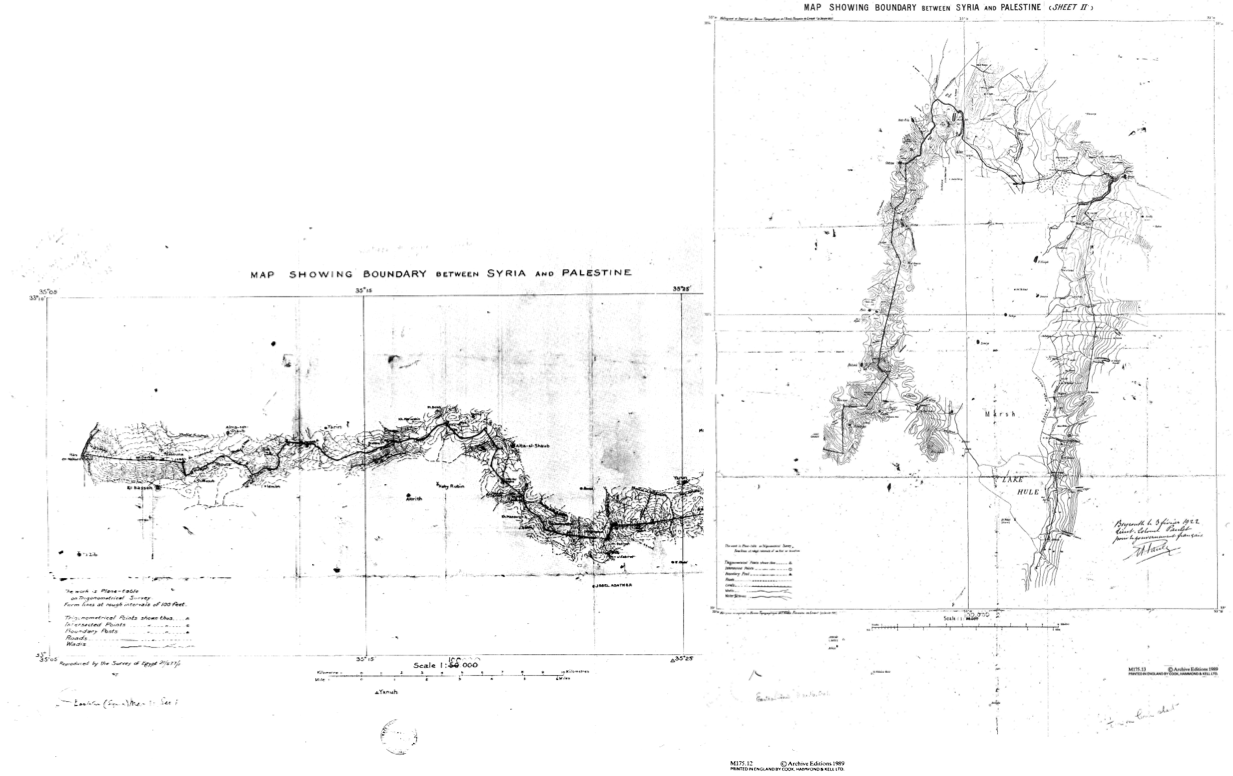
When the British and French governments finished their final negotiations, the borders had been redrawn yet again. The Paulet-Newcombe Agreement removed dozens of villages — and thousands of people — from French Mandate Lebanon and put them in British Mandate Palestine. The British and French approved the new borders on March 7, 1923, and took over their Mandatory territories on September 29 of that year.
Overnight, villagers who had gone to sleep in French Mandate Lebanon woke up in British Mandate Palestine.
The Nakba
A quarter-century later, most of these villages would be ethnically cleansed in the 1948 Nakba, or catastrophe — a series of massacres and mass displacements, carried out by Zionist militias, in the war to seize historic Palestine for the modern-day state of Israel.
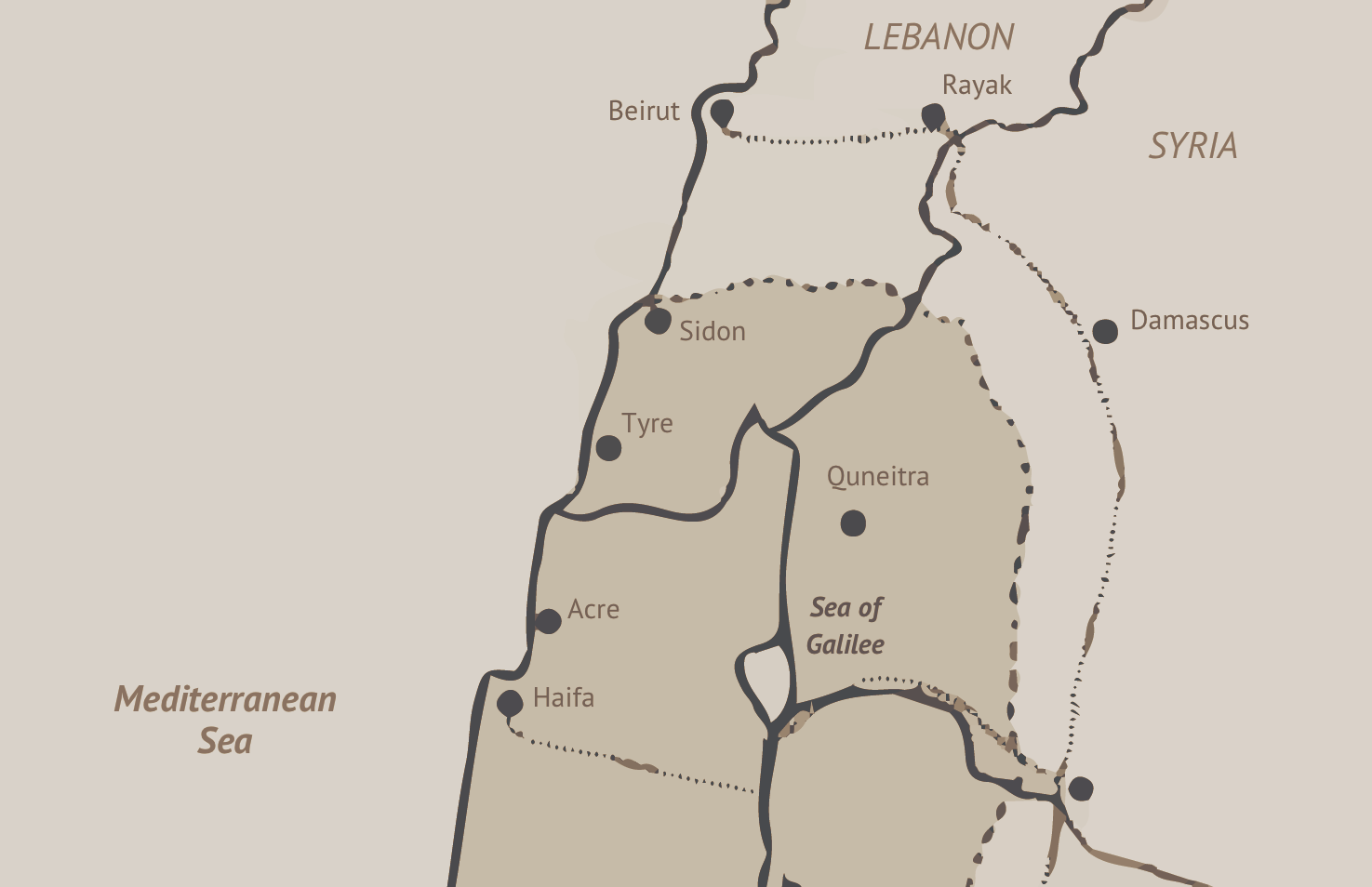
The two maps overlaid here show the new border (the thick gray line) imposed in 1923. In Lebanon, people consider many of the villages in this area to be “lost villages” — Lebanese villages that ended up stranded on the wrong side of the shifting border.
The Line
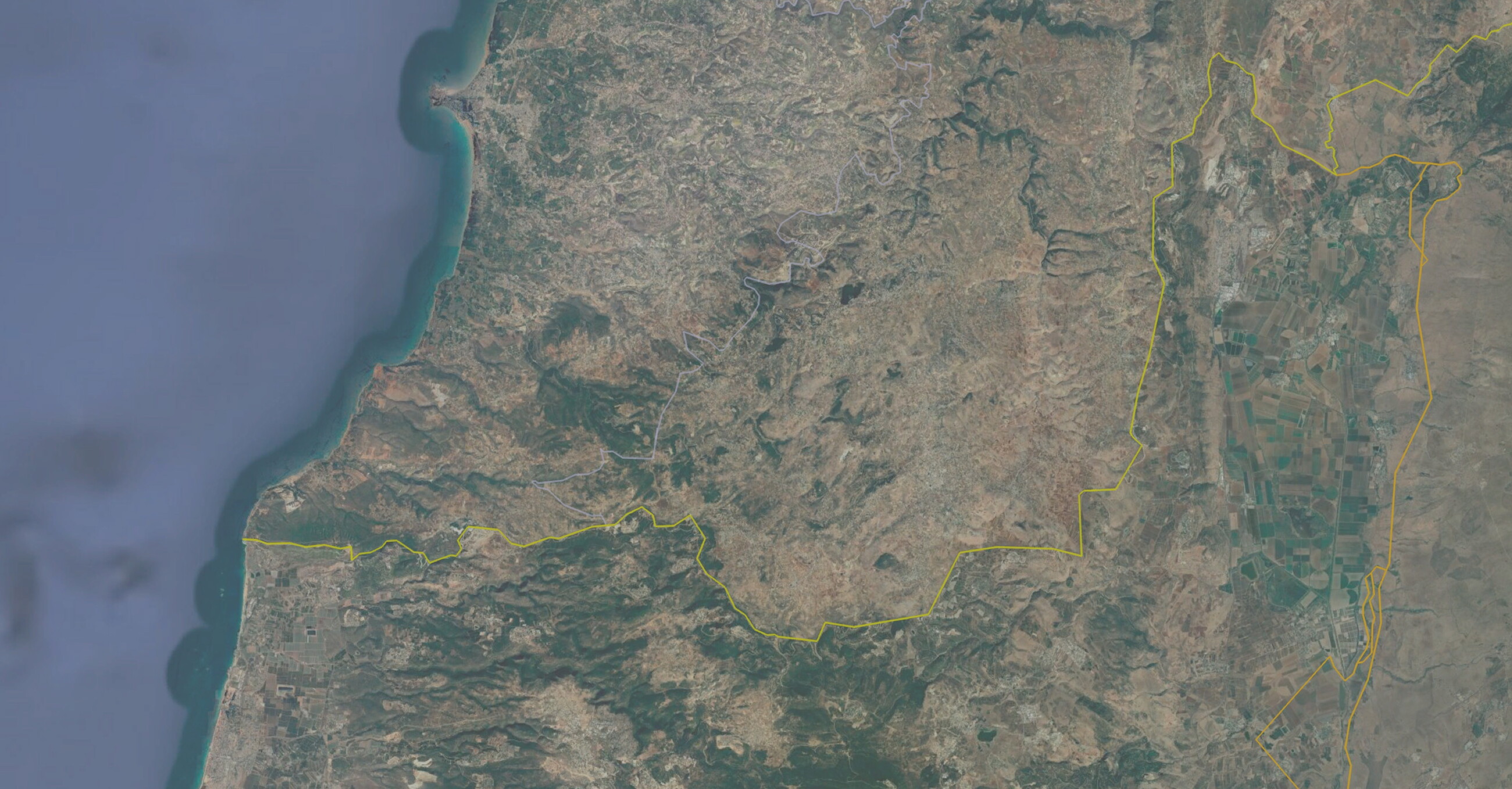
If we look at the current “blue line” (in yellow on the map) that divides present-day Lebanon from present-day Palestine…
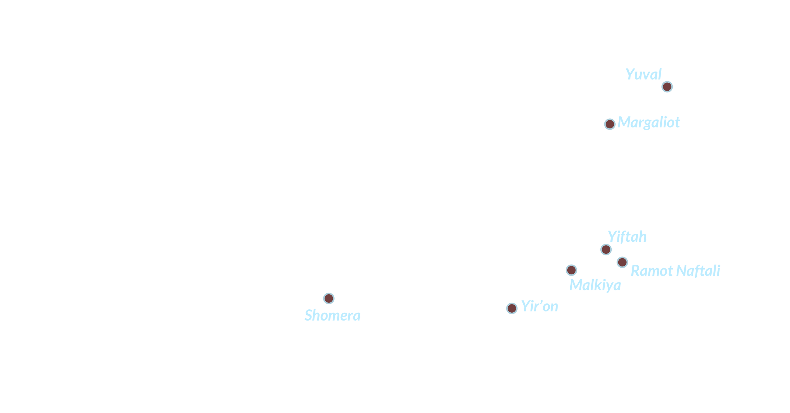
We see a number of Jewish settlements on the southern side of the line: Yuval, Margaliot, Ramot Naftali, Youftah, Malikah, Yiron, Afikim and Choumra.
These are Hebrew names imposed on indigenous Arab villages.
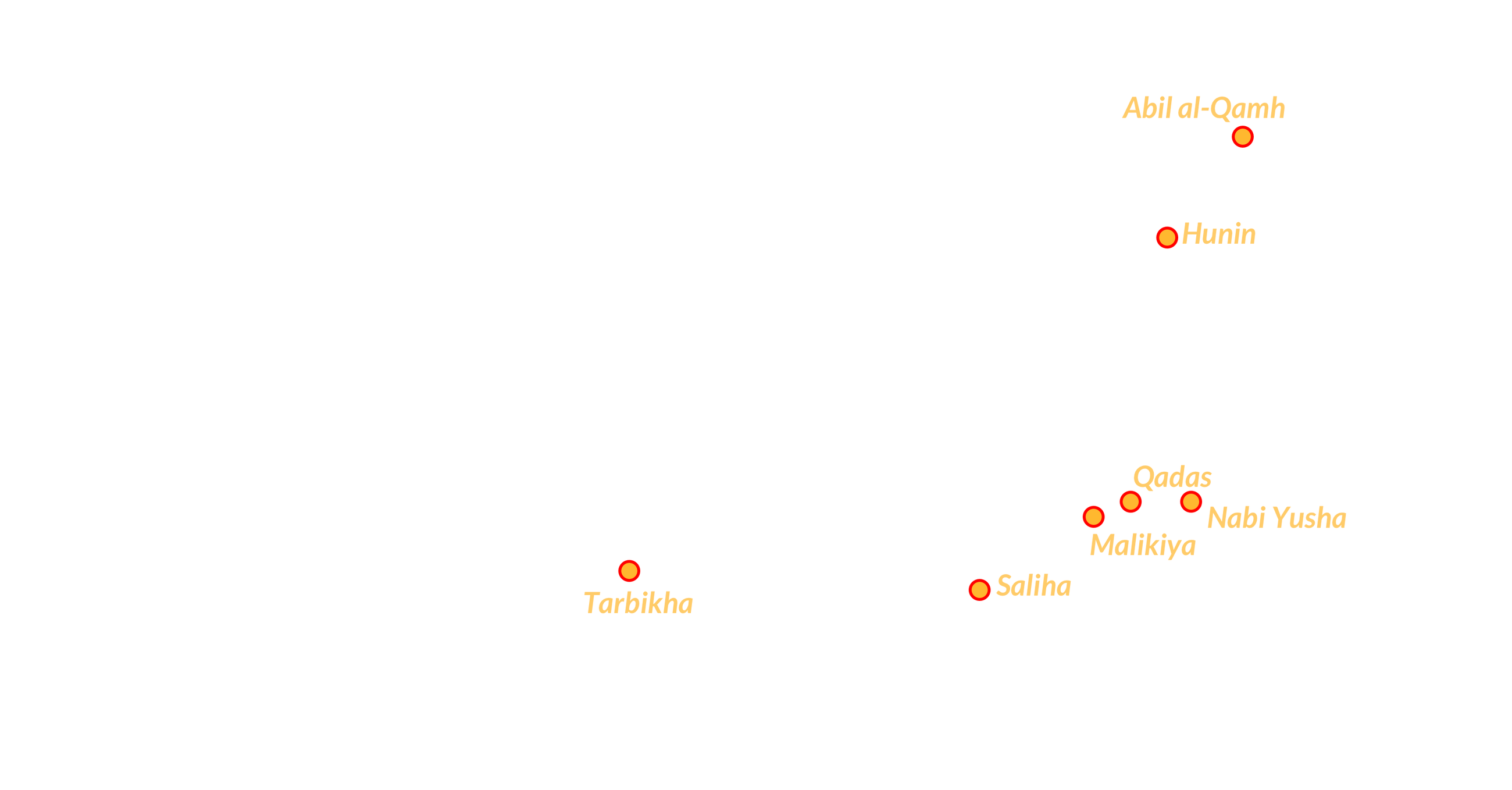
These are the original Arabic names of those villages — the Seven Lost Villages — before they were ethnically cleansed.
The Tragedy of Salha
In the spring of 1948, news of the Deir Yassin massacre began to circulate. On April 9, armed militants stormed the village and massacred at least 107 Palestinians, including many children. Fear rippled across historic Palestine as people worried about meeting a similar fate. In the village of Salha, the Torfa family quickly packed their belongings and fled to Bint Jbeil, the nearest village less than an hour's walk away. A few months later, survivors who made it to southern Lebanon recounted the events in Salha to Hassan Torfa. He, in turn, passed those stories down to his children. More than 75 years later, Hassan’s son, Talal Torfa, recalls the harrowing story:
One night, soldiers from the Sheva’ (Seventh) Brigade — an Israeli occupation forces unit that formed during the 1948 Arab-Israeli War — arrived in armored vehicles. They demanded that Naim Ismael Salami, the village's mokhtar, surrender all the guns in exchange for new identification cards. Salami said he couldn’t locate all the villagers at such a late hour and asked the occupation soldiers to wait until morning. “By then, we will have occupied all of Galilee,” Talal recalls one of them answering.
The militiamen pressed Salami to summon the villagers immediately, claiming they would provide them with new identification cards. Salami instructed the town criers to climb up the mosque’s minaret and ask the villagers to gather in the square outside the mosque. Witnesses later recalled seeing two Israeli soldiers sitting outside a house, casually drinking coffee as the villagers assembled. When some 105 villagers finally gathered outside Salha’s mosque, they found themselves encircled by 10 armored vehicles mounted with heavy machine guns. A commanding officer, addressing the crowd in Arabic, issued an ultimatum, threatening to shoot them if they refused to surrender their weapons. After a few words exchanged in Hebrew with his troops, the officer signaled, and they unleashed a barrage of fire on the villagers.
“Some narrowly escaped by crawling on the ground, hiding, and then managing to run when the militia left,” Talal told The Public Source. The victims included women, men, children, and the elderly. It is said that residents three kilometers away, in the village of Yaroun, heard the screams echoing from Salha. They hurried to transport the wounded to hospitals in nearby villages. The Salha Massacre would mark the first Israeli massacre of Lebanese citizens.

Talal Torfa holds his and his aunt’s (father’s sister) Lebanese IDs and his family’s UNRWA registration card, which they needed before the family was granted Lebanese papers. Torfa recalls stories of his father using binoculars to peek at his school in his occupied village of Salha. March 16, 2024. (Rita Kabalan/The Public Source)
“Foreigners” In Their Own Land
Once in Lebanon, the residents of the seven villages suddenly found themselves classified as Palestinian refugees. Mahmoud Hourani recalls his father, Deeb, mentioning a small minority who obtained Lebanese citizenship “if they had their Lebanese IDs given by the French Mandate and 100 lira.”
“I used to tease my dad, saying he missed out on citizenship because he had the paper but not the money!” Mahmoud said, laughing.
Without citizenship, they faced many restrictions. To this day, Palestinian refugees have limited rights in Lebanon and are barred from working in 39 syndicated professions, including law, engineering, medicine, and the military, as well as from owning property. For decades, they have been forced to rely on services such as healthcare and education from the United Nations Relief and Works Agency for Palestine Refugees (UNRWA), a UN body set up specifically to provide aid to the hundreds of thousands rendered stateless during the Nakba. Hourani also recalled the strict curfew imposed on Palestinians in 1969, which required him to obtain a permit just to leave the house and go to school.
Mahmoud, like other residents of the seven villages, tried to reclaim the Lebanese citizenship that had been granted and later stripped away from them on a whim by the colonial powers and their ever-shifting maps. “I spent a lot of money hiring lawyers to try to regain citizenship,” he said, “but always hit a dead end.” In 1994, then-President Elias Hrawi signed naturalization decree No. 5247 that notably allowed residents of the seven villages, among others, to gain citizenship. The decree, however, excluded hundreds of others, sometimes from the same family, leaving many stateless to this day. Mahmoud and his family were among those included in the decree. “But the decree counted us as foreigners just now receiving Lebanese citizenship,” he said, “not original inhabitants regaining our birthright.”

The Hourani family is one of many clinging to their right of return to their village of Tarbikha.
Just down the road from Mahmoud's house, another remarkable story unfolded. Hassan Torfa, who died in 2023 at the age of 94, cherished his now-destroyed hometown of Salha until his final days. His children say he never gave up hope of returning home — up until his final breath.
Like the Houranis, the Torfa family also settled in Adloun after their expulsion in 1948. The Torfas couldn't afford to buy a house, so the men of the family built one from clay. Hassan’s mother worked as a seamstress; his father had died years earlier. As the eldest son, 12-year-old Hassan became the family's breadwinner.
Young Hassan heard of job opportunities in Adloun, where agriculture flourished, so he started planting, weeding, pruning, and harvesting crops. He would cut down fruits and vegetables, then carry heavy boxes of produce for transport and packing. “My dad stood out, and landowners loved him,” Talal says with pride. “So they started paying him a man's wage, not a child's.” As an adult, Talal recounts how his father befriended statesman and Member of Parliament Adel Osseiran, a prominent figure from a wealthy grain merchant family who served as Speaker of Parliament in the 1950s. In 1982, Osseiran promised to help Hassan and his family regain their citizenship. The Torfas had held Lebanese IDs in Salha, but after their displacement, the state denied their children the same status.
Osseiran petitioned then-president Elias Sarkis to issue a special naturalization decree for the Torfa family. But Sarkis hesitated: the country was in the midst of a brutal civil war. Right-wing Christian militias, backed by Israel, were waging war against Palestinian factions and committing violent attacks against Palestinian refugees in Lebanon. Sarkis suggested Osseiran consult with Bachir Gemayel, leader of the Lebanese Forces militia, the paramilitary wing of the right-wing Christian Kata’eb or Phalange Party. The story goes that Osseiran and Gemayel had a good relationship. And so, with Gemayel’s approval, President Sarkis signed the decree granting citizenship to the Torfa family. Later that year, in September, Gemayel was assassinated. The Lebanese Forces, in collusion with the Israeli army, proceeded to carry out the mass killing of Palestinian refugees, now known as the massacre of Sabra and Shatila.
Memories of Salha
The Salha massacre left a deep and lasting wound in Hassan Torfa's heart. “He could never get over the unfairness and the injustice,” Talal says. “I don't recall my dad having a day of ease knowing Israel continued to exist." Determined to lift his family out of poverty, Hassan prioritized his siblings’ education and started saving money. By 1976, he had saved L.L. 5,000 (around $1,741 at the time) to buy a small house, and 70,000 lira ($24,376) to buy 15 dunams (15,000 square meters) of land.
Known as “Abu el-Abed,” after his eldest son Abed al-Karim, Hassan’s life improved. Married and a father of 14 children, he became a prominent landowner in Adloun. To this day, his sons continue his legacy through the plantations in Adloun and Sarafand. Hassan often visited the village of Maroun el-Ras, where he could gaze across the border at Salha, now replaced by the Israeli settlements of Yir’on and Avivim. There, he would recount to his children and grandchildren the locations and stories of how everything once stood.
“He would use binoculars and point to the school he used to attend, still visible to this day,” Talal recalled. His father kept his grandfather's ID, showing Salha's inclusion in the southern Lebanese district of Sur, as well as papers proving the family's land ownership. He also held onto vivid memories of the expansive hills where his family once kept beehives, the store his father owned during his prosperous days as a trader in Salha, and the slow-paced life shaded by olive and fig trees, amid flourishing tobacco fields and abundant harvests.
Abu el-Abed passed away on March 20, 2023, from lung cancer. Yet his memories and love of Salha live on through his children and grandchildren, despite being scattered around the world.

The banana fields of Adloun gave work to families like the Houranis and the Torfas, who were expelled from their villages of Tarbikha and Salha respectively, in 1948. March 16, 2024. (Rita Kabalan/The Public Source)
Liberation's Reignited Hopes
The fate of the Houranis and the Torfas reflects the shared experiences of most residents from the seven villages who sought refuge in neighboring towns and villages and went on to rebuild their lives. Many resettled in villages across southern Lebanon, only for their descendants to endure 18 years of brutal Israeli occupation starting in 1982. During the occupation, life in southern Lebanon was marked by constant fears for survival and frequent violent attacks, even in densely populated areas such as bustling markets.
The South Lebanese Army (SLA), a far-right Christian militia operating as an Israeli proxy, ran the infamous Khiam Prison, notorious for its use of torture. Prisoners were stripped naked, soaked with hot and cold water, and subjected to electric shocks. The SLA detained some 5,000 people, including 500 women, during its collaboration with the Zionist regime.
On May 25, 2000, after nearly two decades of fierce resistance by Hezbollah and historically by Palestinian factions and leftist and secular militant groups, Israeli occupation forces were finally forced to withdraw from southern Lebanon. The United Nations established the 120-kilometer-long Blue Line that same year, which to this day does not constitute an official border, but a “line of withdrawal."
Among the seven villages, Tarbikha and Hunin saw over 2,000 dunams of land (approximately 2 square kilometers) return to Lebanese sovereignty, while the remaining and larger parts remained under Israeli occupation. The liberated areas consist only of small open plains on the outskirts of the original villages. The largest agricultural fields, along with the village streets, homes, and shops, now marked by stone ruins, remain under Israeli control.
Hunin, the largest of the seven villages, has a rich history dating back to the late 12th century. Travelers described it as a picturesque village, nestled alongside the ruins of a Crusader castle — a testament to its ancient heritage and archaeological significance. Perched atop a low hill, Hunin once thrived amidst lush greenery, with its fertile lower valley supporting vibrant crops of grains, vegetables, and fruits.
These images of Hunin haunted Jihad Chahrour. Although having never set foot in his ancestral village, the liberation of the South in 2000 was a catalyst for him to try and reclaim his hometown.

Jihad Chahrour and his son at their home in Dahieh. Chahrour bought land from relatives in the liberated part of Hunin, where he built a prayer site with other Hunin residents. He later constructed his own home, which was destroyed by Israeli forces in January 2024. Since then, Chahrour has been unable to return to his home in Hunin. March 28, 2024. (Rita Kabalan/The Public Source)
The Chahrour family worked in trade and agriculture. Stories passed down through generations describe Hunin as a bustling trade hub connecting Lebanon and Palestine. In early May 1948, however, rumors spread that Zionist forces had reached the Houla Valley. The residents of Hunin knew their village would be next. “My family left thinking they would return soon,” Jihad told The Public Source.
The family initially resettled on the outskirts of the village, in a small field adorned with olive and fig trees. Stranded without their keys or official documents, the family waited, believing their displacement would be temporary. What started as a brief interruption stretched into days and then weeks. They pitched tents, hoping the violent attacks would subside, but within a month, it became clear they needed to look for a more permanent refuge.
They sought refuge in southern villages such as Kherbet Selem and Deir al-Zahrani. Jihad’s maternal family eventually settled in Tal al-Zaatar, while his paternal relatives found refuge in Ghobeiry, both located outside of Beirut. The Chahrours were naturalized by the 1994 decree despite not having Lebanese IDs from the period of the French mandate.
Even as a child, Jihad understood the profound historical significance of his hometown and the injustice his family had suffered due to Zionist settler-colonial violence. In 1984, when he was just five years old, his family took him to the southern border for a glimpse of their native village. Jihad vividly recalls his frustration and anger when his football rolled beyond the border.
“I started crying, thinking the Zionists now owned my ball,” he said.
A Dream Come True
As the years passed, Jihad's resentment only grew. The liberation of the South in 2000 made him ask: What if… What if Hunin could be revived and reclaimed, even within the limits of a small plot of liberated land?
In the years following Israel’s defeat, Jihad and his family visited the liberated areas sporadically, limited by financial constraints and his responsibilities running his family's junkyard business. But, in 2016, Jihad stumbled upon Facebook posts of people visiting the liberated parts of Hunin and sharing photos of themselves simply sitting in the open, barren lands with a direct view of the settlement of Margaliot.
It was a turning point. Jihad immediately joined them, starting a tradition of gathering in the area, bringing along a few chairs to sit on for a few hours. “It would be a waste if this land ended up unused,” he thought to himself.
Jihad began taking his family, then friends and neighbors, to the site. Together, they erected a tent on the liberated land at the outskirts of their ancestral village. Though the land belonged to Jihad's maternal and paternal families, not him directly, their tent formed a new center for the village — a gathering place for the people of Hunin to hold weekly reunions.
“I always wondered what it would be like to have a hometown, growing up without one,” Jihad said. “My parents' constant talk of the village fueled this eagerness even more.”
Jihad bought a portion of the land from his relatives. With financial and practical help from other Hunin residents, they built a prayer site on the land, complete with running water and toilets to accommodate visitors. What started with 20 cars parking in the area soon swelled to 300. Brief visits evolved into full days of storytelling, laughter, lunches, ataba singing, dabke dancing, and Ashura gatherings. Whether in the depths of winter, or under the scorching summer sun, the people of Hunin had finally found a place to meet and reconnect with their roots.


By 2019, Jihad had saved enough money to build a house — what he believes to be the first home erected on Hunin’s lands, on the Lebanese side of the Blue Line, since 1948. “I had in mind to fulfill my mom's wish of planting her plot of land,” he said.
A three-story house with terracotta roof tiles, a pool, a decorative well, a traditional clay oven, and a garden, Jihad’s home is only a few kilometers away from settler homes in Margaliot, which he remarks are built with white stones in European architectural styles, encircled by fields of purple wildflowers and vast expanses of greenery. Jihad's home crowns the hilltop, looking down at the occupiers who have encroached upon his ancestral land.
The meandering road along the Blue Line runs only a few meters downhill from Jihad’s home — an easy walk, in fact. A few kilometers away stands the al-Abad Israeli military base, towering behind a three-meter-tall cement wall dividing south Lebanon from historic Palestine.
“My parents were overjoyed; they used to join me every weekend,” Jihad said of the early years in his new home. “My mother would pick fruits and vegetables,” he added, beaming with pride, “as her dream finally came true.”
Inevitable Return
Since October 7, 2023, Israel’s genocidal war on Gaza has devastated the besieged population of the Strip. While official reports cite nearly 43,000 deaths, some estimates suggest the toll may be closer to 92,000. This war has extended into Lebanon, leading to over 3,500 fatalities so far.
Jihad and his family have been unable to visit Hunin since the outbreak of the war. On January 29, 2024, he received a phone call from the Lebanese military informing him that his house had sustained some damage. “I told them not to lie, and to just say that it was completely destroyed,” he told The Public Source. He paused and drifted into a vacant stare, struggling to put his feelings into words. “No more large gatherings in Hunin. No more dreams come true.” Instead, he now stays in Beirut, where he reminisces about the past — feeling as though history is repeating itself: a reality once again snatched away by Israel. “Is this how my ancestors felt?” he wondered aloud, his voice tinged with heartbreak and disbelief.
But Jihad is not yet ready to admit defeat. “At the earliest opportunity I get, I'll immediately start rebuilding the house,” he vowed. “The fact that we're there, overlooking the Israeli settlement, is itself a form of resistance, and we'll make sure it continues this way.”
The Israeli occupation continues to wreak havoc on the lives of Palestinians and Lebanese. One of its stated objectives is to turn the border villages of southern Lebanon into a barren buffer zone, uninhabitable by its people.
Although Israel razed the seven villages to the ground, some historical sites remain, repurposed by the Zionist regime into tourist attractions. In Qadas, the remnants of a Roman temple stand as silent witnesses to ancient times. Nearby, the shrine of Prophet Yusha in Nabi Yusha reflects the village’s religious history. Hunin’s Crusader fortress looms as a testament to its rich political past.
In Salha, the school, a long building with hollowed windows, stands as the village's final, haunting remnant. The round dome of Tarbikha’s mosque peeps out in overgrown shrubbery. In al-Malikiyya, scattered stone remains faintly echo the lives once lived there, while very very little remains of Abil al-Qamh.
Despite the physical erasure of their villages, memories endure. Families like the Torfas, Houranis, and Chahrours have not abandoned their claims to their lands and continue to keep their history alive.
Memories of Tarbikha, where Deeb Hourani used to attach tobacco rolling paper to the wings of bees to help locate wild beehives, or of Salha, where Abu el-Abed excelled in his first English lessons, live on long after the original inhabitants have passed.
Fatima, the 94-year-old, recalls riding a horse from her hometown of Kneisseh to Tarbikha for her wedding, dressed in her bridal gown and holding an umbrella to shelter her from the sun. Villagers welcomed her in the village square, dancing the dabke to the melodic voice of a female singer, her tune reminiscent of the folkloric Dal'ouna.
The traditions, lifestyles, mannerisms, and local recipes of Tarbikha closely resembled those of Fatima’s original hometown of Kneisseh, in what is now southern Lebanon. “It was literally the same life,” she said. “They were masters of making Saj in Tarbikha.” Her son, Mahmoud, has authored a book titled “The Case of the Seven Villages” and organized many initiatives to support the people of Tarbikha in Lebanon.
From humble beginnings in a tent, Mahmoud Hourani now owns a large home. Yet, his greatest dream remains to return to his ancestral land. “Hope keeps growing by the day, especially amid the ongoing war,” he said. “Justice must return to its rightful owners.”
Share this page